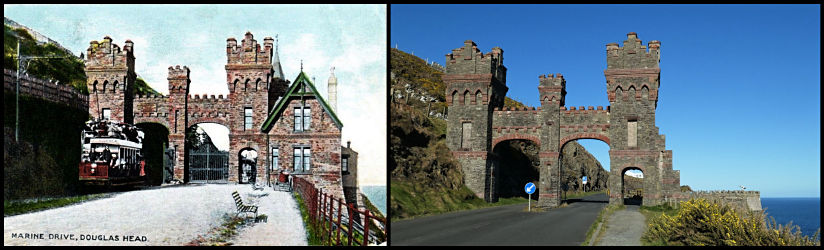
The
Douglas Southern Electric Tramway ran from Douglas Head and south along
the Marine drive for around four an a half miles to a terminus on the cliffs
above
Port
Soderick. In UK terms it was the island's only Standard Gauge (4'
8.5") railway, although IOM Standard gauge was and is 3'
The
idea for this website section came about when I was asked to supply an
Image of Little Ness for an animation project by Stuart Green.
'All
aboard for an animated trip along the Marine Drive!'
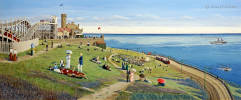 Douglas Head by Stuart
Green.
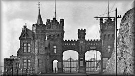
The
Marine Drive itself opened in 1893, the same year as the Manx Electric
Railway started running from Douglas to Groudle, it had required a lot
of rock blasting work
and
the construction of two wooden viaducts over the Port Wallberry and Horse
Leap inlets.
The
electric tramway followed, having an official opening on the 16th July
1896, the same year that the Manx Electric Railway reached Laxey.
The company
had
to generate its own electrical power and a power station was constructed
at the Pigeon Stream. Another problem was where to build the depot
and the
only
suitable flat piece of land was deemed to be at Little Ness, somewhat inconveniently
located along the line, closer to Port Soderick than Douglas.
The
line was single tracked with passing loops and operated seasonally until
the end of August 1939 but never re-opened after WW2. It was probably
too
badly damaged by wartime use of the Marine Drive by the Royal Navy and
would have cost a fortune to restore to operation.
It
was lifted in the 1950s and most of the rolling stock scrapped, but tram
No 1 was preserved and is now located in the UK at the Crich
Tramway Village.
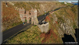
The
roadway was widened and opened to motor vehicles with the old viaducts
by-passed, but today the centre section is pedestrian only due to landslips.
For
a better description of the Marine Drive and the tramway, I can recommend
George Hobb's excellent 'By Whing to Port Soderick',
published
by Loaghtan Books, which was
a great help with producing the photo captions here. More recently
I was given a copy of
'Double
Century' by Stan Basnett and Keith Pearson, published in 1996. This
excellent book covers both the DSET and the Upper Douglas Cable Tramway,
but
is probably had to come by now.
The
modern pictures are all by me, older ones are from my collection.
You can just follow
the links all the way through, starting with the maps below. The Aerial
shots were taken between 2016 & 2022 at various seasons.
Most of the old tramway
shots have present day equivalents, click on the actual pictures to toggle
between the two.
Douglas Head by Stuart
Green.
The
Marine Drive itself opened in 1893, the same year as the Manx Electric
Railway started running from Douglas to Groudle, it had required a lot
of rock blasting work
and
the construction of two wooden viaducts over the Port Wallberry and Horse
Leap inlets.
The
electric tramway followed, having an official opening on the 16th July
1896, the same year that the Manx Electric Railway reached Laxey.
The company
had
to generate its own electrical power and a power station was constructed
at the Pigeon Stream. Another problem was where to build the depot
and the
only
suitable flat piece of land was deemed to be at Little Ness, somewhat inconveniently
located along the line, closer to Port Soderick than Douglas.
The
line was single tracked with passing loops and operated seasonally until
the end of August 1939 but never re-opened after WW2. It was probably
too
badly damaged by wartime use of the Marine Drive by the Royal Navy and
would have cost a fortune to restore to operation.
It
was lifted in the 1950s and most of the rolling stock scrapped, but tram
No 1 was preserved and is now located in the UK at the Crich
Tramway Village.
The
roadway was widened and opened to motor vehicles with the old viaducts
by-passed, but today the centre section is pedestrian only due to landslips.
For
a better description of the Marine Drive and the tramway, I can recommend
George Hobb's excellent 'By Whing to Port Soderick',
published
by Loaghtan Books, which was
a great help with producing the photo captions here. More recently
I was given a copy of
'Double
Century' by Stan Basnett and Keith Pearson, published in 1996. This
excellent book covers both the DSET and the Upper Douglas Cable Tramway,
but
is probably had to come by now.
The
modern pictures are all by me, older ones are from my collection.
You can just follow
the links all the way through, starting with the maps below. The Aerial
shots were taken between 2016 & 2022 at various seasons.
Most of the old tramway
shots have present day equivalents, click on the actual pictures to toggle
between the two.
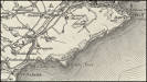 1906 Map of the Marine
Drive
1906 Map of the Marine
Drive
|
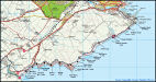 2009 Map of the Marine
Drive
2009 Map of the Marine
Drive
|
The 2009 map shows the
Marine Drive with significant points on the Douglas Southern Electric Tramway
marked.
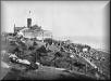
The photographs are
divided between three galleries, firstly the old photos and with their
'today' equivalents, then the aerial shots, going from Douglas Harbour
and the Bay, down to
Port Soderick, and back again with Panoramas. Finally a small
section of older pictures of Douglas Head, the harbour ferries and Douglas
Beach.
 The Tramway Old/New
Ground Pictures
The Tramway Old/New
Ground Pictures
|
 The Aerial Pictures
|
 Old pics from Douglas
Head to the Beach
Old pics from Douglas
Head to the Beach
|
|